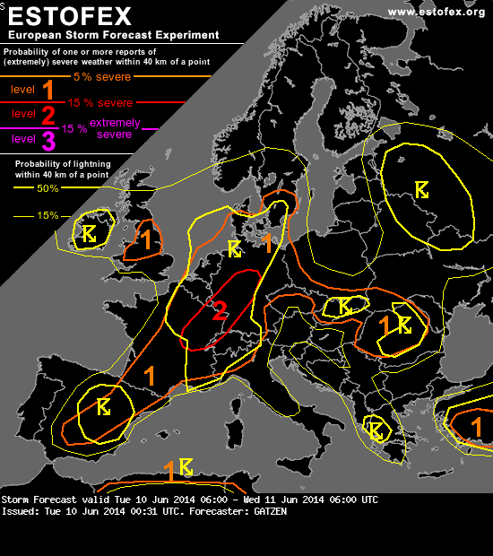
Storm Forecast
Valid: Tue 10 Jun 2014 06:00 to Wed 11 Jun 2014 06:00 UTC
Issued: Tue 10 Jun 2014 00:31
Forecaster: GATZEN
A level 2 was issued for eastern France, south-western and central Germany mainly for large hail, excessive precipitation, and severe wind gusts.
A level 1 was issued for Germany, southern Scandinavia, Benelux, northern and central France, and southern Poland mainly for large hail and severe wind gusts.
SYNOPSIS
High geopotential stretches from the west Mediterranean to Austria and Czech Republic. It is flanked by a polar trough over western Russia and an Atlantic trough that yields a deep south-westerly flow over western Europe. An embedded short-wave trough is moving from western France to southern Scandinavia on Tuesday. Ahead of this trough, warm air advection will support an intensification and amplification of the European high.
At lower levels, an elevated mixed layer will spread northwards into central and eastern Germany. It will partly overlap with rich boundary-layer moisture present along a frontal boundary from south-west France to north Germany.
DISCUSSION
South-western, central, and eastern France, the Alps, Benelux, most of Germany, Denmark, southern Sweden
At the start of the day, current storms will still affect parts of the forecast area, especially parts of northern and cdentral Germany into western Poland. Large hail and local severe wind gusts are possible. Behind the remaining of these storms, low-level cold air advection sets in over most of France, the Benelux countries, and western and north-western Germany, and a weak low-pressure center spreads into central Germany. From south-eastern France to the Alps and south-eastern Germany, very warm air will remain. Diurnal heating may also lead to low-level mixing over central and eastern Germany, where outflow of overnights storms will be present on Tuesday morning.
Weak QG lift is expected during the day as the anticyclonically sheared flank of the mid-level jet streak overspreads the area. However, frontogenitical lift can be supposed along the cold front and outflow boundaries and may support some storms, especially over central France and Benelux. Every storm that forms to the north-west of the low-level frontal boundary will profit from veering profiles and augmented vertical wind shear, reaching 120 m²/s² and 15 m/s in the lowest 3 km. Supercells capable of producing large or very large hail as primary threat are therefore not ruled out. A tornado is also not excluded with the best potential near old outflow boundaries.
Additional storms are forecast to form over parts of the Alps, especially over eastern France, Switzerland, and western Austria, but also over southern Poland due to upslope flow. These storms will pose a threat of severe wind gusts and large hail as they form in a deeply mixed unstable air mass.
Main activity is expected in the evening and night hours in the wake of the short-wave trough due to the QG lift underneath the right entrance region of the mid-level jet streak. Together with warm air advection, steep lapse rates will be in place over the moist boundary layer, resulting in 30 hPa MLCAPE of more than 1000 J/kg well into the night.
Current thinking is that storms over the western Alps and along the frontal boundary will merge in the evening and night hours and will spread north-east into Germany. Favourable QG lift is expected to support an MCS moving east-north-east, although vertical wind shear will be rather weak with only 10 to 15 m/s in the lowest 6 km. Main threat seems to be severe wind gusts together with excessive rain, but also large hail is possible. Until the morning, this system is expected to move into north-east Germany or western Poland and maybe even into eastern Denmark and southern Sweden.
