dan gelukkig niet met de sterkte van nu. 
000
WTNT42 KNHC 040232
TCDAT2

Hurricane Kirk Discussion Number  19
NWS National Hurricane Center Miami FL       AL122024
1100 PM AST Thu Oct 03 2024

Kirk continues to prosper.  The earlier eyewall replacement cycle
appears to have completed, and Kirk is back on a strengthening
trend.  Satellite images indicate that Kirk has a circular and
clear 15 n mi eye surrounded by a solid ring of intense deep
convection.  The latest satellite intensity estimates range from
115 to 135 kt, and based on that data, the initial wind speed is
increased to 125 kt.

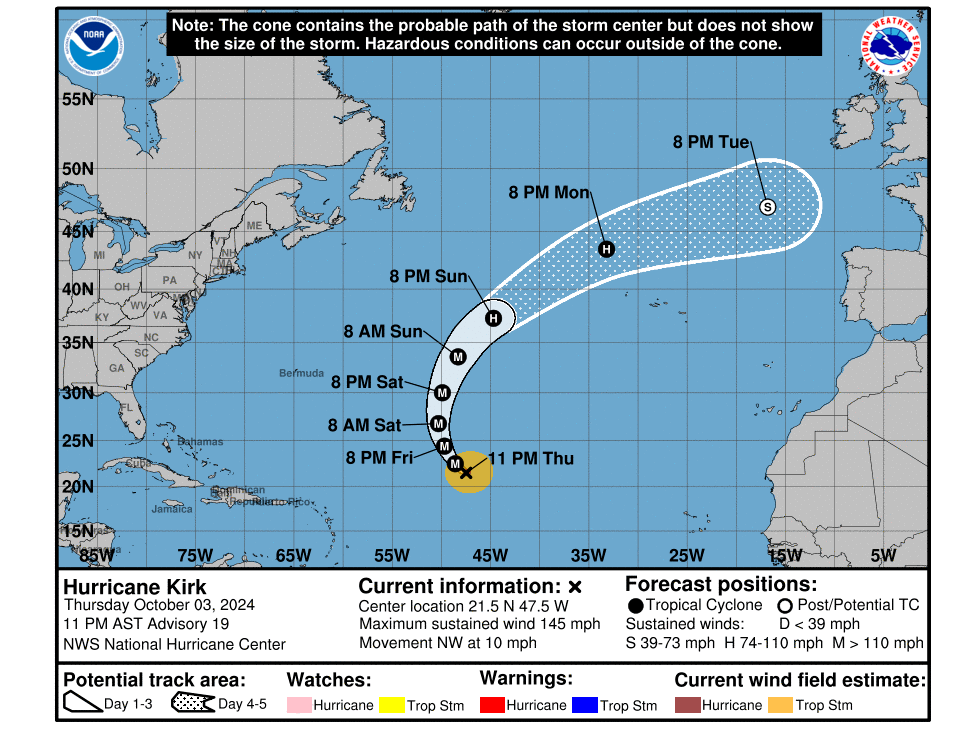
The hurricane is moving northwestward at 9 kt, and this general
motion should continue through Friday as Kirk continues to move
along the southwestern periphery of a high pressure ridge over the
central and eastern subtropical Atlantic.  A turn to the north is
expected on Saturday when Kirk reaches the western periphery of the
ridge and as a shortwave trough approaches the system.  This trough
and a reinforcing one should cause the hurricane to accelerate
northeastward on Sunday and early next week.  The models are in
fairly good agreement on this overall scenario, and the NHC track
forecast has been nudged westward to be in better agreement with
the latest model runs.

Kirk could strengthen a little more during the next 12 hours or so,
but increasing vertical wind shear and intrusions of dry air should
cause a steady weakening trend to begin shortly after that.  Kirk
will likely complete extratropical transition when it moves
over cool waters sometime between day 4 and day 5, but it is
expected to remain a powerful system throughout the forecast
period.  The NHC track forecast is in best agreement with the HCCA
and IVCN consensus models.

Even though Kirk is expected to stay over the open Atlantic, its
strong intensity and increasing size will cause large ocean swells
to propagate far away from the hurricane.   These swells will likely
increase the risk of dangerous surf and rip currents across the
Leeward Islands beginning Friday, Bermuda and the Greater Antilles
by Saturday, and much of the U.S. East Coast, Atlantic Canada, and
the Bahamas by Sunday.  For more information on this hazard, see
products issued by your local weather office.


FORECAST POSITIONS AND MAX WINDS

INIT  04/0300Z 21.5N  47.5W  125 KT 145 MPH
 12H  04/1200Z 22.5N  48.6W  135 KT 155 MPH
 24H  05/0000Z 24.4N  49.7W  130 KT 150 MPH
 36H  05/1200Z 26.8N  50.3W  120 KT 140 MPH
 48H  06/0000Z 30.0N  49.9W  110 KT 125 MPH
 60H  06/1200Z 33.6N  48.3W  100 KT 115 MPH
 72H  07/0000Z 37.3N  44.7W   90 KT 105 MPH
 96H  08/0000Z 43.5N  33.2W   75 KT  85 MPH
120H  09/0000Z 47.0N  16.8W   60 KT  70 MPH...POST-TROP/EXTRATROP

$$
Forecaster Cangialosi

